(Created page with "captionUm in die 3D Ansicht zu wechseln tippen Sie auf dem Icon auf der Symbolleiste. <br /> ;# GS Fahrtmesser ;# Instrumente ein- oder ausblenden <nowik...") |
(Created page with "<nowiki>*</nowiki> Beim Tippen auf diesem Button werden das Moving Map und Route auf der rechten Seite ein- oder ausgeblendet.") |
||
| Line 21: | Line 21: | ||
;# Status-Button | ;# Status-Button | ||
| − | <nowiki>*</nowiki> | + | <nowiki>*</nowiki> Beim Tippen auf diesem Button werden das Moving Map und Route auf der rechten Seite ein- oder ausgeblendet. |
---- | ---- | ||
Revision as of 15:35, 20 October 2016
Das EFIS Modul besteht aus einer grafischen Benutzeroberfläche, welche das Gelände in 3D während des Fluges anzeigt. Um diese Funktion zu benutzen, müssen Sie zuerst die 3D Daten vom Map Store herunterladen. Dies sind komplexe Daten, die sowohl für das EFIS-Modul sowie auch für den Höhenprofil funktionieren. Sobald Sie diese Daten in Air Navigation Pro installiert haben, brauchen Sie die "Free Elevation data" nicht mehr zu installieren.
Übersicht
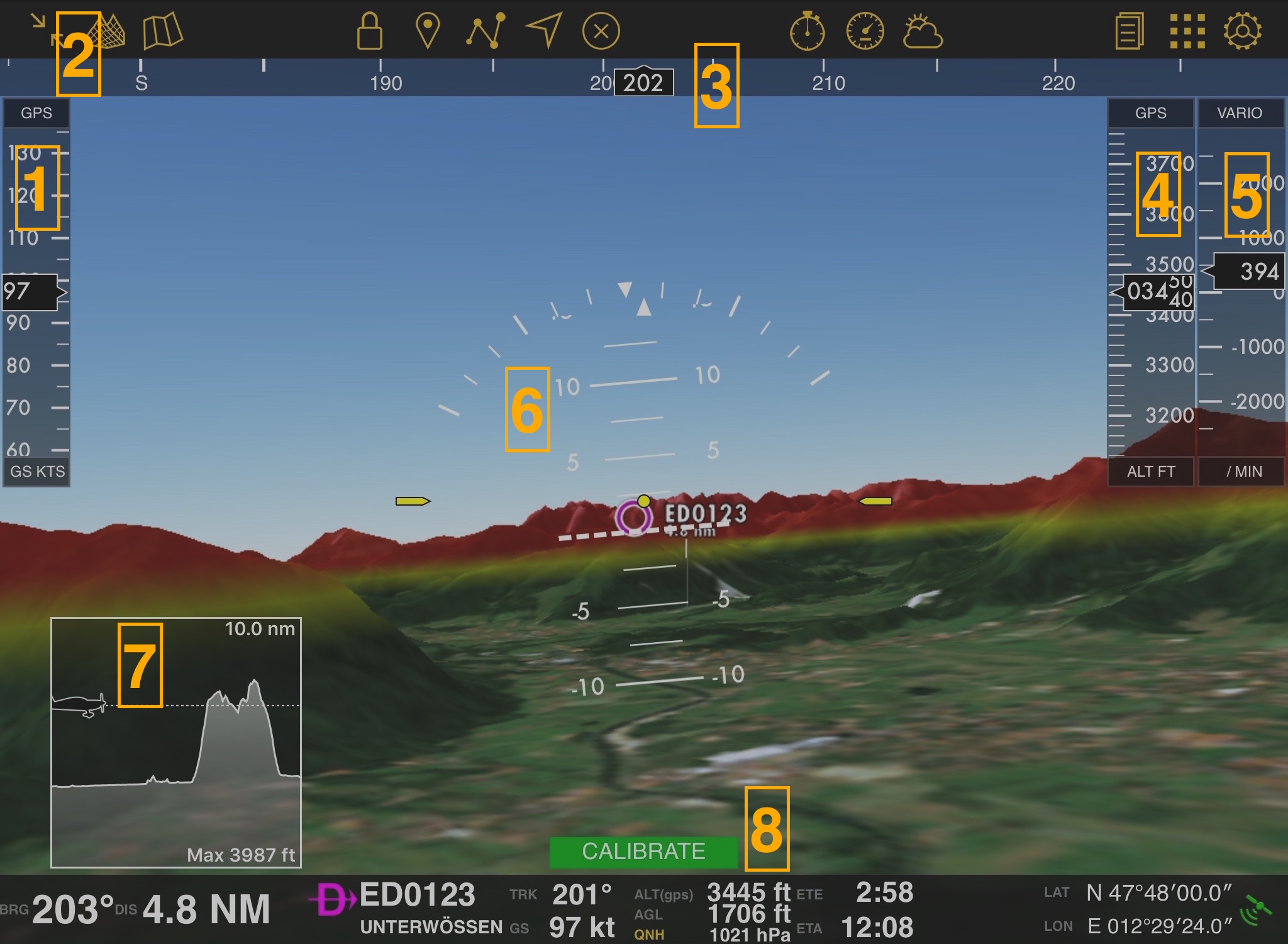
Um in die 3D Ansicht zu wechseln tippen Sie auf dem Icon auf der Symbolleiste.
- GS Fahrtmesser
- Instrumente ein- oder ausblenden *
- Kursanzeige
- Höhenmesser
- Variometer
- Künstlicher Horizont
- Höhenprofil
- Status-Button
* Beim Tippen auf diesem Button werden das Moving Map und Route auf der rechten Seite ein- oder ausgeblendet.
Different modes and calibration
You might see the following:
![]() Will be displayed when touching the Edit Mode button.
Will be displayed when touching the Edit Mode button.
You can freely navigate throughout the terrain in this mode:
- Touching the screen and dragging up or down will change the pitch.
- Touching the screen and dragging left or right will change the heading.
- Touching the altitude bar and dragging up or down will change the altitude.
- By touching on the left edge of the EFIS and dragging up or down you can move forward or backwards
![]() Press it and a menu will open. You will be able to calibrate the attitude and the offset.
Press it and a menu will open. You will be able to calibrate the attitude and the offset.
![]() This will show when using an AHRS G mini gadget.
This will show when using an AHRS G mini gadget.
![]() You will show when using Air Navigation Pro with X-Plane.
You will show when using Air Navigation Pro with X-Plane.
![]() You will show it when using Air Navigation Pro with FSX.
You will show it when using Air Navigation Pro with FSX.
Troubleshooting
- The attitude is freezed and there is a red button with the message "Attitude OFF".
- It's possible that the internal gyroscope is turned off or there is no connection to the external AHRS sensor. Make sure to activate them through "Tools - Sensors" under the sub-menu "Attitude Sources".
Back to previous page.

