| (One intermediate revision by one other user not shown) | |||
| Line 2: | Line 2: | ||
<translate> | <translate> | ||
<!--T:1--> | <!--T:1--> | ||
| + | <br /> | ||
---- | ---- | ||
[[File:flightinfo.jpg|caption|left|250px]]The flight information module displays a list of real time navigation values in digital form. | [[File:flightinfo.jpg|caption|left|250px]]The flight information module displays a list of real time navigation values in digital form. | ||
| Line 14: | Line 15: | ||
---- | ---- | ||
<br /> | <br /> | ||
| − | Back to <u>[[ | + | Back to <u>[[Instruments|previous page.]]</u> |
</translate> | </translate> | ||
Latest revision as of 20:35, 10 March 2016
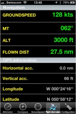
The flight information module displays a list of real time navigation values in digital form.
It will also compute the flown distance since the application startup or from the moment the current flight was restarted in the «Flight time» module.
At the bottom part, you will find the GPS horizontal and vertical accuracy as well as the coordinates of the current location, as reported by the GPS subsystem.
Back to previous page.
