| Line 4: | Line 4: | ||
| − | + | [[Map Options]] displays the map settings module. In the map settings you can configure what will be displayed on the map and how. | |
| − | + | ||
| − | + | ||
| Line 14: | Line 12: | ||
__NOTOC__ | __NOTOC__ | ||
=='''Map modes'''== | =='''Map modes'''== | ||
| + | === Brightness === | ||
| + | You can adjust the brightness of the app from here | ||
=== Map background === | === Map background === | ||
Enables or disables the screen background. | Enables or disables the screen background. | ||
=== Elevation graph === | === Elevation graph === | ||
Enables or disables the terrain elevation graph for both [[Moving Map]] & [[3D View]]. | Enables or disables the terrain elevation graph for both [[Moving Map]] & [[3D View]]. | ||
| − | |||
=== Terrain awareness 2D/3D === | === Terrain awareness 2D/3D === | ||
| − | Enables or disables the terrain awareness for both | + | Enables or disables the terrain awareness for both [[Moving Map]] and [[3D View]]. |
| − | + | ||
=== Show METAR on map=== | === Show METAR on map=== | ||
| − | Displays icons over the Airports according to the weather conditions (VMC | + | Displays icons over the Airports according to the weather conditions (V for VMC, I for IMC, M for Marginal VMC) on the map. Internet connection is needed to use this feature |
---- | ---- | ||
=='''Map settings'''== | =='''Map settings'''== | ||
=== [[Airspaces]] === | === [[Airspaces]] === | ||
| − | |||
=== [[Waypoints]] === | === [[Waypoints]] === | ||
=== [[Obstacles]] === | === [[Obstacles]] === | ||
Revision as of 21:53, 9 March 2016
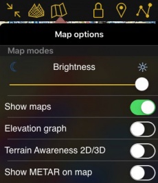
Map Options displays the map settings module. In the map settings you can configure what will be displayed on the map and how.
Map modes
Brightness
You can adjust the brightness of the app from here
Map background
Enables or disables the screen background.
Elevation graph
Enables or disables the terrain elevation graph for both Moving Map & 3D View.
Terrain awareness 2D/3D
Enables or disables the terrain awareness for both Moving Map and 3D View.
Show METAR on map
Displays icons over the Airports according to the weather conditions (V for VMC, I for IMC, M for Marginal VMC) on the map. Internet connection is needed to use this feature
Map settings
Airspaces
Waypoints
Obstacles
Traffic awareness
Widgets
Maps
Background
Back to previous page.
