(Marked this version for translation) |
|||
| Line 1: | Line 1: | ||
<languages /> | <languages /> | ||
<translate> | <translate> | ||
| + | <!--T:1--> | ||
<br /> | <br /> | ||
---- | ---- | ||
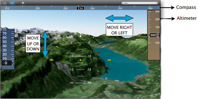
The 3D view module is a useful tool that complements the Elevation graph when performing a flight plan. It uses a commercial-grade quality digital elevation model together with good quality satellite photos. The result is a very realistic representation of the world in 3D at a resolution of 15m per pixel (photos) and 90m grid for the elevation. | The 3D view module is a useful tool that complements the Elevation graph when performing a flight plan. It uses a commercial-grade quality digital elevation model together with good quality satellite photos. The result is a very realistic representation of the world in 3D at a resolution of 15m per pixel (photos) and 90m grid for the elevation. | ||
| + | <!--T:2--> | ||
[[File:danger.jpg|caption|left]] The 3D view comes with '''no 3D data installed.''' 3D data is available for purchase on a per-country or per-region basis in the Map Store. | [[File:danger.jpg|caption|left]] The 3D view comes with '''no 3D data installed.''' 3D data is available for purchase on a per-country or per-region basis in the Map Store. | ||
<br/> | <br/> | ||
| Line 10: | Line 12: | ||
<br/> | <br/> | ||
| + | <!--T:3--> | ||
Use your mouse to '''look up or down''' in the view, move right or left to have a wider look of the terrain and use the mouse wheel to '''climb up or down.''' | Use your mouse to '''look up or down''' in the view, move right or left to have a wider look of the terrain and use the mouse wheel to '''climb up or down.''' | ||
<br/> | <br/> | ||
Latest revision as of 20:53, 13 October 2015
The 3D view module is a useful tool that complements the Elevation graph when performing a flight plan. It uses a commercial-grade quality digital elevation model together with good quality satellite photos. The result is a very realistic representation of the world in 3D at a resolution of 15m per pixel (photos) and 90m grid for the elevation.
The 3D view comes with no 3D data installed. 3D data is available for purchase on a per-country or per-region basis in the Map Store.Use your mouse to look up or down in the view, move right or left to have a wider look of the terrain and use the mouse wheel to climb up or down.
Back to index
