(Created page with "<br /> ---- 250pxTDer Altimeter von Air Navigation basiert wie alle Navigationsinstrumente auf den GPS-Daten. Normalerweise hat das GPS ein...") |
(Created page with "Das Altimeter von Air Navigation zeigt die Höhe über dem Meer ('''HüM''') gemäss GPS an. Normalerweise hat die angegebene Höhe eine '''Genauigkeit von 70 Fuss oder wenige...") |
||
| Line 2: | Line 2: | ||
<br /> | <br /> | ||
---- | ---- | ||
| − | [[File:altimeter.jpg|caption|left|250px]] | + | [[File:altimeter.jpg|caption|left|250px]]The Altimeter of Air Navigation is GPS based like all navigation instruments. Usually, the GPS has an acceptable precision. Nevertheless it should never be used as a replacement for the barometric altimeter. |
| − | + | Das Altimeter von Air Navigation zeigt die Höhe über dem Meer ('''HüM''') gemäss GPS an. Normalerweise hat die angegebene Höhe eine '''Genauigkeit von 70 Fuss oder weniger'''. Die Genauigkeit ist mit externen GPS-Modulen noch besser. | |
The top part is the analog altimeter indicator. On the bottom part you will find the digital altimeter value as well as the current GPS status symbol. | The top part is the analog altimeter indicator. On the bottom part you will find the digital altimeter value as well as the current GPS status symbol. | ||
Revision as of 17:49, 18 December 2015
The Altimeter of Air Navigation is GPS based like all navigation instruments. Usually, the GPS has an acceptable precision. Nevertheless it should never be used as a replacement for the barometric altimeter.
Das Altimeter von Air Navigation zeigt die Höhe über dem Meer (HüM) gemäss GPS an. Normalerweise hat die angegebene Höhe eine Genauigkeit von 70 Fuss oder weniger. Die Genauigkeit ist mit externen GPS-Modulen noch besser.
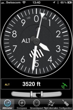
The top part is the analog altimeter indicator. On the bottom part you will find the digital altimeter value as well as the current GPS status symbol.
The altimeter unit can be set as feet or meters in the application settings.
- GPS accuracy is more than 230 ft.
Note: remember that you will ONLY find the spinball at the bottom of the instrument on iPhone/iPod Touch devices.
Back to index
