(Created page with "Criar uma rota") |
(Created page with "<br /> ---- Estes são os passos para criar uma rota em Air Nav Desktop: # Na aba “Mission”, selecionar o módulo «Route» # Escolher um waypoint do mapa que você deseje...") |
||
| Line 2: | Line 2: | ||
<br /> | <br /> | ||
---- | ---- | ||
| − | + | Estes são os passos para criar uma rota em Air Nav Desktop: | |
| − | # | + | # Na aba “Mission”, selecionar o módulo «Route» |
| − | # | + | # Escolher um waypoint do mapa que você deseje adicionar a uma rota |
| − | # | + | # Selecionar o botão «Add» da janela pop-up |
| − | # | + | # O waypoint será adicionado à lista da rota |
| − | # | + | # Alternativamente, é possível adicionar um waypoint através do campo de pesquisa |
| − | # | + | # A distância total e o tempo estimado é mostrado na parte superior do módulo de rota |
| − | # | + | # A distância parcial e o tempo estimado por perna é mostrado no canto esquerdo de cada waypoint |
| − | # | + | # A rota também pode ser exibida no gráfico do terreno. |
| − | <br/> | + | <br /> |
| − | [[File:danger.jpg|caption|left]] | + | [[File:danger.jpg|caption|left]] O gráfico de terreno mostrará a informação só se os dados de elevação tem sido instalados. |
| − | <br/> | + | <br /> |
| − | [[File:danger.jpg|caption|left]] | + | [[File:danger.jpg|caption|left]] Os tempos estimados serão mostrado só se a velocidade cruzeiro for enchida no perfil da aeronave. |
| − | <br/> | + | <br /> |
[[File:mac1mac.jpg]] | [[File:mac1mac.jpg]] | ||
Revision as of 15:34, 24 November 2015
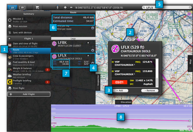
Estes são os passos para criar uma rota em Air Nav Desktop:
- Na aba “Mission”, selecionar o módulo «Route»
- Escolher um waypoint do mapa que você deseje adicionar a uma rota
- Selecionar o botão «Add» da janela pop-up
- O waypoint será adicionado à lista da rota
- Alternativamente, é possível adicionar um waypoint através do campo de pesquisa
- A distância total e o tempo estimado é mostrado na parte superior do módulo de rota
- A distância parcial e o tempo estimado por perna é mostrado no canto esquerdo de cada waypoint
- A rota também pode ser exibida no gráfico do terreno.
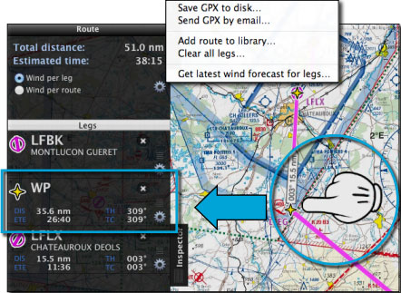
From the top, there’s a menu available with these options:
- Save as GPX file to disc
- Send GPX file by Email
- Add route to the Library TAB
- Clear route
- Get latest wind forecast
You can add mid waypoints to a route using the mouse to press, hold and move the leg to a position in the map.
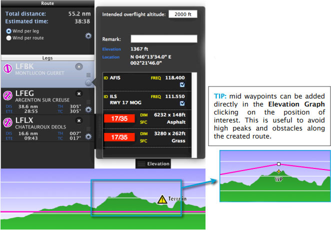
You can have access to a window with info for each waypoint in the route module. Remarks can be added there and the intended overflight altitude can be set, too.
Levels restrictions are set from Map TAB > Elevation module.
Back to index


