(Created page with "Sehr schwaches Signal") |
(Created page with "250px Für die Echtzeit-Navigation muss das GPS Symbol <span style="color:green">'''grün'''</span> oder <span style="color:yellow">'''...") |
||
| Line 44: | Line 44: | ||
Sehr schwaches Signal | Sehr schwaches Signal | ||
| − | [[File:moving_map6.jpg|caption|right|250px]] | + | [[File:moving_map6.jpg|caption|right|250px]] Für die Echtzeit-Navigation muss das GPS Symbol <span style="color:green">'''grün'''</span> oder <span style="color:yellow">'''gelb'''</span> sein. Ein <span style="color:red">'''rotes'''</span> oder <span style="color:orange">'''orangenes'''</span> kann nur die geschätzte Position aber keine Informationen zur Geschwindigkeit oder zur Flugroute anzeigen. |
| − | For better results, place your device near a window, with a direct view of the sky. | + | For better results, place your device near a window, with a direct view of the sky. Für bessere Angaben sollten Sie Ihr Gerät in der Nähe eines Fensters mit direktem Sichtkontakt zum Himmel platzieren. Wenn Sie mit einem Flugzeug aus reinem Metall fliegen oder Ihr Flugzeug eine Anti-Frost Scheibenfolie hat, kann das interne GPS-Signal des Tablet/mobilen Gerät schwächer ausfallen und ein externes GPS-Modul erforderlich machen. |
| − | + | ||
---- | ---- | ||
Revision as of 19:54, 18 November 2015
Sie können durch die Moving Map eine Route erstellen. Es ist auch möglich dazwischenliegende Wegpunkte auf der aktuellen Route, während des Fluges, zu setzen. (um schlechte klimatische Bedingungen zu vermeiden)
Durch Drücken des Kompassrose Symbols in der oberen rechten Ecke des Bildschirms können Sie zwischen folgenden Einstellungen wechseln:
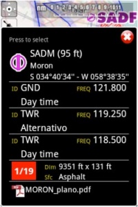
Touching an area of interest on the map will reveal a popup window with useful information. Touchable or interactive items are:
Wegpunkte: ID Code, Höhe, Symboltyp, vollständigen Namen, Breite, Länge, Frequenz (Navaids), Landebahn und Frequenz-Informationen (Flughafen), georeferenzierte Anflugkarten.
Luftraum: untere und obere Grenzen, Name, Klasse und zusätzliche Informationen. Diese Lufträume sind auf der Karte in verschiedenen Farben je nach Klasse aufgezeichnet.
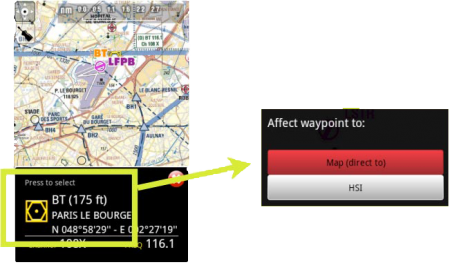
Drücken Sie auf irgendein Wegpunkt der Karte um ihn zum HSI Instrument hinzu zufügen oder um ihn als Ziel zu setzen. Klicken Sie Press to select um ihn auszuwählen.
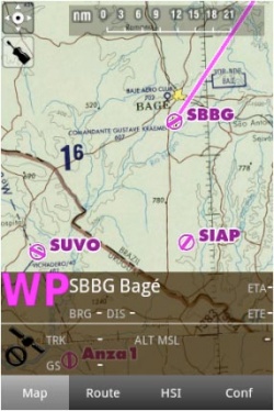
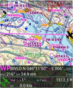
Die Datenleiste am unteren Bildschirmrand der Moving Map zeigt Ihnen Echtzeit-Informationen. Von links nach rechts: ID und Name des nächsten Wegpunkts; Richtung, Kurs und Entfernung zu diesem; Geschwindigkeit und Höhe aus dem GPS und die geschätzte fehlende Zeit bis zum nächsten Wegpunkt.
Die Datenleiste informiert Ihnen auch über die Qualität des GPS:
Ausgezeichnetes Signal
Gutes Signal
Schwaches Signal
Sehr schwaches Signal
Für die Echtzeit-Navigation muss das GPS Symbol grün oder gelb sein. Ein rotes oder orangenes kann nur die geschätzte Position aber keine Informationen zur Geschwindigkeit oder zur Flugroute anzeigen.For better results, place your device near a window, with a direct view of the sky. Für bessere Angaben sollten Sie Ihr Gerät in der Nähe eines Fensters mit direktem Sichtkontakt zum Himmel platzieren. Wenn Sie mit einem Flugzeug aus reinem Metall fliegen oder Ihr Flugzeug eine Anti-Frost Scheibenfolie hat, kann das interne GPS-Signal des Tablet/mobilen Gerät schwächer ausfallen und ein externes GPS-Modul erforderlich machen.
Back to index.


