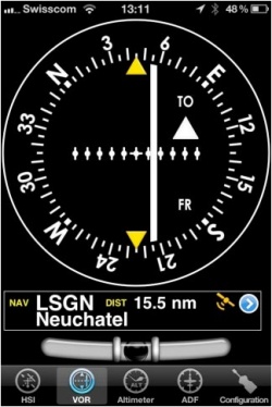
(Created page with "---- 250pxO instrumento VOR usa dados do GPS para mostrar o rumo para um waypoint. A parte superior é um emulador dum indicador VOR. A agulha...") |
(Created page with "leftA '''“NAV” warning flag''' will let you know that you should '''NOT''' trust the VOR indicator in the following cases: * '''Nenhum waypoint...") |
||
| Line 8: | Line 8: | ||
[[File:danger.jpg|caption|left]]A '''“NAV” warning flag''' will let you know that you should '''NOT''' trust the VOR indicator in the following cases: | [[File:danger.jpg|caption|left]]A '''“NAV” warning flag''' will let you know that you should '''NOT''' trust the VOR indicator in the following cases: | ||
| − | * ''' | + | * '''Nenhum waypoint''' selecionado para o instrumento; |
| − | * | + | * A distância para o waypoint selecionado é '''maior do que 250 milhas náuticas'''; |
| − | * | + | * '''A precisão do GPS é''' menor às 2.5 milhas náuticas. |
Revision as of 16:11, 17 November 2015
O instrumento VOR usa dados do GPS para mostrar o rumo para um waypoint.
A parte superior é um emulador dum indicador VOR. A agulha branca (CDI, Indicador do Desvio do Curso) exibirá o desvio atual até +/- 12 graus do radial ou desde o waypoint selecionado. A seleção do radial e do curso é feita ao tocar e arrastar os dedos para baixo e para cima na parte esquerda ou direita do anelo da bússola. Embaixo do indicador principal, o nome do waypoint atual selecionado é exibido, como assim também a distancia desde o waypoint (circulo grande) e a precisão do GPS. Você pode usar qualquer tipo de waypoint (Aeroportos, VOR, NBD, etc.) com o instrumento VOR (enquanto um indicador VOR necessita sinais de rádio desde transmissores VOR, VOR/DME ou VORTAC). Você pode selecionar um waypoint novo desde a base de dados com o botão azul na parte inferior do instrumento. Por favor, leia«Procurar/Selecionar waypoints» para obter mais informação sobre a pesquisa e seleção de waypoints.
A “NAV” warning flag will let you know that you should NOT trust the VOR indicator in the following cases:- Nenhum waypoint selecionado para o instrumento;
- A distância para o waypoint selecionado é maior do que 250 milhas náuticas;
- A precisão do GPS é menor às 2.5 milhas náuticas.
Note 1: you don’t need Ground speed to get accurate information on this instrument.
Note 2: remember that you will ONLY find the spinball at the bottom of the instrument on iPhone/iPod Touch devices.
Back to index
